TV32 is constantly being updated to include new, useful features. These features are developed based on requests from sponsors of the Maritime Safety and Security Information System (MSSIS). While the basic function of TV32 is to display contacts on a Graphical User Interface (GUI), TV32 is also capable of:
|
|
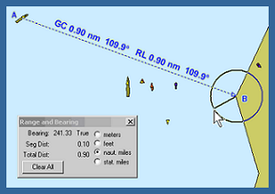
Finding the range and bearing using TV32's distance measurement tools |
- calculating the distance between any two points on the display.
- determining the meeting point, closest point of approach, estimated time of arrival, and cross track error of any contacts on the display.
- exporting data to OTH Gold, XML, or KML to be interpreted by another program. This can be done by streaming or by taking "snapshots" at fixed intervals.
- exporting contacts and their information (i.e. size, heading, etc.) to Google Earth via a KML file.
- monitoring the streams of data to determine statistics. This data includes latency, any outages, the number of unique contacts, and data flow rates from the source.
- recording and playing back logged data.
- sounding an alarm if a potential hazard could occur from a ship entering or leaving a zone specified by the user.